Bitter Cold Hits Tri-State As Another Storm Looms
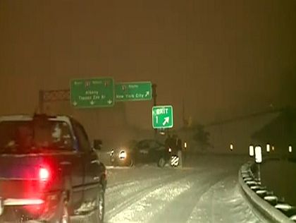
NEW YORK (CBS New York) -- The latest winter storm to hit the New York City area dumped several inches of snow and caused some treacherous road conditions for commuters on Friday before moving out quickly.
What will follow this weekend will have a definite feel of serious winter. CBSNewYork.com's team of meteorologists were calling for temperatures in the teens overnight Friday and a high of just 21 on Saturday, under mostly sunny skies. The situation was not expected to improve much on Sunday, with the high only reaching 25.
The National Weather Service said wind chills could make it feel like temperatures in the single digits all weekend.
AccuWeather meteorologist Dr. Joe Sobel said Monday morning could be one of the coldest the area has had in the last few years. Some rural areas could see a low of zero and 10 degrees in the city with real feel temperatures even lower than that.
On Tuesday, the Big Apple can expect more snow as a nor'easter heads toward the area. "The storm track is going to be forming along the Gulf Coast states then riding up the eastern seaboard," AccuWeather's Jim Kosek said. "So unlike storm systems which sometimes produce a mixed bag of precipitation this one is going to be all snow." Tuesday's storm may rival the post-Christmas blizzard. Click here for more from AccuWeather.
According to computer monitors and some forecasters, depending on the track of the storm, there could be a significant amount of snowfall but it's still too early to tell.
CBSNewYork.com's team of meteorologists is calling for Arctic temperatures on Saturday and Sunday
Podcast
WCBS 880's Sean Adams in Orangetown
LISTEN: Craig Allen's Weather To Go
As for Friday morning's snow and where it puts the area now for the season, the National Weather Service said the snow stopped in the city at 7:40 a.m. Central Park got 4.2 inches. JFK and LaGuardia airports got more than 3 inches. The storm was expected to end eastern Long Island by midmorning, with accumulations of 3-5 inches.
Central Park has received 36.1 inches of snow so far this season, according to the National Weather Service, with most coming during the post-Christmas blizzard that dumped more than 2 feet of snow on some parts of the city. The city has had five smaller storms since December. The average snowfall for December, January and February -- dating to 1890 -- is 21 inches, the NWS said. The city is fast approaching totals from the 2009-2010 season, when it got 51.4 inches.
Podcast
WCBS 880's Paul Murnane in Stamford
Useful Links: Alerts | Closings & Delays | Traffic & Transit | Radar Map
Many schools on Long Island and in Westchester and Rockland counties were closed or had delayed openings.
New York City's Office of Emergency Management issued a Hazardous Travel Advisory due to possibly dangerous travel conditions for the Friday morning rush hour. Alternate side parking regulations are suspended.
Sanitation Commissioner John Doherty said Friday there wasn't as much snow as predicted and the snowfall wasn't as fast.
Mayor Michael Bloomberg reminded property owners that they must clear snow from the sidewalks in front of their buildings. He says, "Doing it today will be easy. Doing it tomorrow is going to be much harder.''
Bloomberg is also warning New Yorkers that a blast of cold over the weekend will freeze any slushy snow and make roads and sidewalks treacherous.
Stick with CBSNewYork.com for the latest on the storm with updates from our weather team at CBS 2, 1010 WINS and WCBS 880.