New Maps Reveal Dramatic Post-Sandy State Of Fire Island
NEW YORK (CBSNewYork) - The first detailed scientific scan showing the extent of superstorm Sandy's wrath has been released, and some of the most dramatic changes are on Fire Island.
WCBS 880's Wayne Cabot With The Story
Podcast
The United States Geological Survey has been doing laser measurements to show the before and after and have produced a new map of the south shore of Long Island.
"The entire coastline along Fire Island has basically been reconfigured. The dunes have moved substantially landward. A lot of the beach has eroded. And it's very dramatic in terms of the amount of change during the course of just one storm," the USGS's Dr. Cheryl Hapke told WCBS 880's Wayne Cabot.
She said a lot of the dunes overwashed completely, but where there are still little remnants of dunes, those dunes moved landward about 70 feet. That's about 30 years worth of change.
What does this say when it comes to preparing for the next storm?
"Well, it specifically can give us information about where the coast might be more vulnerable for future storms, where the elevation is substantially lowered and where it doesn't seem to be coming back very rapidly, those might be areas that could be the most at-risk during the next big storm," she said.
Does that mean things shouldn't be rebuilt there?
"Well, I can't make that sort of recommendation in terms of do or don't rebuild, but it's just to simply state that those are areas that are likely to be impacted greatly in another event," she said.
One idea suggested by another researcher is that for areas like that that are low-lying, only five to ten feet above sea level, that they only put temporary structures there. Those are the type that you can bring out in the summer and haul away in the fall.
"That's absolutely one option. I've been in different places of the world, even in developing countries, where they do just that along their coastline. So, that's something that should be brought into the conversation as we decide how we're going to respond in the future to this storm," Hapke said.
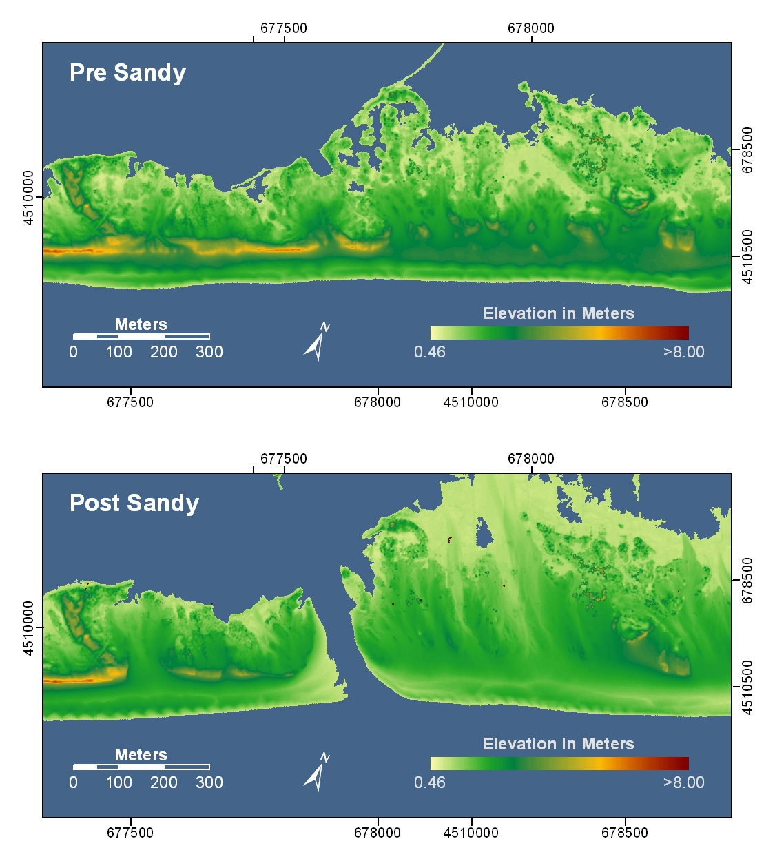
Cabot also asked, "What do you make of that new breach on Fire Island? Isn't that amazing?"
LINK: More Imagery From USGS
"Yeah, that is. It's truly amazing and one of the most interesting things about it is the fact that at least right now, it's being left to behave naturally," she said. "So, the fact that that breach, where there's water flowing between the ocean and the bay can be left to work its natural course is a really good thing, a very positive thing."