Bitter Cold Overnight; Snowstorm To Kick Off Next Week
NEW YORK (CBNewYork) -- The clear skies and balmy temperatures of last weekend will seem like a distant memory in the days to come, with dangerous winds and bitter cold, and a major snowstorm coming just in time for the new work week next week.
As of 11 p.m. Thursday, the temperature had dropped to 16 degrees. Waking up Friday morning, the temperature could set a record for the date as it drops to 7 degrees, with wind chills below zero for the entire area.
The wind had decreased in intensity from earlier in the night, when an arctic front brought sustained speeds of 20 to 30 mph gusting up to 40 to 45 mph. Earlier in the evening, winds on the West Side of Manhattan blew violently from the west and began knocking things over.
Conditions are expected to be clear with a high of 22 degrees on Friday, followed by highs of 34 on Saturday and 35 on Sunday.
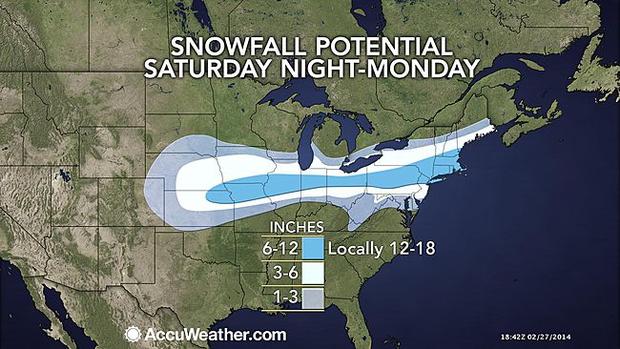
But then, a major snowstorm Sunday evening through Monday is expected to cause huge disruptions from Chicago to New York City, according to AccuWeather.
The heaviest snow is likely to fall Monday afternoon into evening in the coastal Northeast, said Expert Senior Meteorologist Alex Sosnowski.
Snowfall rates at the height of the storm may reach 2 inches per hour, according to AccuWeather.
The storm is likely to impact travel, school and business activities, Sosnowski said.
The power of the storm is dependent on two high-pressure systems that will be hovering over the Tri-State Area.
"The challenge with this storm is figuring out where the north-south boundary between rain and snow will set up and migrate to as the storm progresses slowly eastward," said AccuWeather Chief Meteorologist Elliot Abrams.
If the high-pressure system to the north prevails, it could pull down cold air and bring snow totals of a foot or more, Quinn reported.
If the system to the south prevails, the snow and ice will be balanced out by warm air and rain, and snow totals could amount to as little as 2 to 4 inches.
The forecast models Thursday night were showing dramatic differences in projections. The European Model was predicting a heaping 9.6 inches of snow for the city, while the North American Mesoscale Forecast System model was showing only 0.5 inches of snow.
Based on current models, Quinn earlier forecast 4 to 8 inches of snow are likely to fall in the city during the storm Sunday and Monday.
You May Also Be Interested In These Stories: