Winter Blast On Tap For Tuesday; Some Could See A Foot Of Snow
NEW YORK (CBSNewYork) - Another snowstorm could blanket much of the region, and has prompted a winter storm warning.
The winter storm warning was issued beginning at noon Tuesday for the five boroughs of New York City, the northern suburbs, all of Long Island, most of New Jersey, and southern and eastern Connecticut.
The warning continues until 6 a.m. Wednesday. The National Weather Service warned that snow accumulations could top out at 10 to 14 inches.
As CBS 2's Elise Finch reported, a storm system that was blowing over Minnesota and Iowa Monday afternoon was taking a southerly track and intensifying overnight. Combined with an area of low pressure moving in from the south, a major snowstorm will result.
Winter Blast On Tap For Tuesday; Some Could See A Foot Of Snow
CBS 2's Lonnie Quinn said light snow will arrive around noon. Heavier snow will first appear in New Jersey around 2 p.m. as the storm approaches from the south, followed by heavier snow in New York City and on Long Island around 4 p.m.
The snow is expected to taper off overnight.
Estimates Monday evening indicated that the northern suburbs and parts of northern New Jersey will see the most modest totals, with 3 to 5 inches. New York City proper, areas just to the west and much of central New Jersey will see totals of 5 to 8 inches.
On Long Island, snow totals may top out at 8 to 12 inches.
But Quinn said the snow will fall for a long period of time, and totals could be even higher than what the computer models showed Monday.
Winds from the north will blow in at 20 to 30 mph, with gusts of up to 35 mph, the NWS said. Wind chills will drop as low as minus 5 late Tuesday night.
The New York City Department of Sanitation has issued a snow alert starting at 9 a.m. Tuesday. To prepare for the expected snowfall, sanitation workers will begin filling up 365 salt spreaders, attaching plows to trucks and putting chains on tires.
New York City alternate side parking will also be suspended Tuesday, but meters will be in effect.
The Metropolitan Transportation Authority was also preparing all the railroad and transit systems, and bridges, that it controls. Deicers have been prepared on the New York City subway system, and extra bus drivers and mechanics will be brought in.
Extra engineers and signal maintainers have also been sent in to keep the Metro-North Railroad and Long Island Rail Road running.
A total of 7,250 tons of salt and an array of snow-fighting has also been brought in for the city's bridges and tunnels.
The Port Authority of New York and New Jersey has also announced its readiness plan, including beefed up staffing at airports, bridges, tunnels and PATH trains.
The Port Authority has the following snow equipment and supplies ready at its major transportation facilities:
- More than 200 pieces of snow equipment at its airports, including melters that can liquefy up to 500 tons of snow an hour and plows that can clear snow at 40 mph;
- Approximately 60 pieces of snow equipment at its bridges and tunnels, including nearly two dozen plows and spreaders at the George Washington Bridge, the world's busiest vehicle crossing;
- Thousands of tons of salt and sand for airport roads and parking lots, and for bridges and tunnels;
- Plow-equipped trains, liquid snow-melting agent trains and a "jet engine" plow to remove snow from PATH tracks, and snow blowers, plows and spreaders to clear station entrances, roads that serve PATH's 13 stations, and various support facilities.
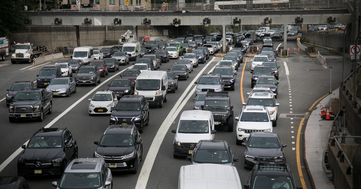
And as CBS 2's Carolyn Gusoff reported, Monday was a legal holiday. But that did not stop crews from gearing up and pre-treating the Long Island Expressway and other state roads in preparation for the winter blast.
Meanwhile, Mike Catons of West Babylon was stocking up with rock salt for his driveway and other essentials.
"Fill up the cars, make sure we got gas, all that kind of stuff," Catons said.
As CBS 2's Dave Carlin reported, the New York State Department of Transportation called in crews Monday to pre-treat the state roads on Long Island with brine – a saltwater mixture that creates a barrier between the road surface and snow.
They have also called in the heavy artillery -- extra snow and ice crews and extra plows from upstate -- to help tackle Long Island roads.
No decision has been made yet on a travel ban like the one issued for the Long Island Expressway earlier this month. But state Department of Transportation officials are urging drivers to be snow ready and take it slow.
Towns and counties were also prepping for all hands on deck.
"We're going to prepare like it's going top be a foot. We're hoping for, obviously, six to eight inches," said Town of Babylon Public Works Commissioner Tom Stay. "But in either case, we're going to have all of our trucks plowed up. Our salt and sand is ready to go, and all our staff is on standby."
Stay said it was wind that made the last snowstorm with a foot of blowing snow so challenging. This time, the wind is not expected to be as fierce.
"We had some heavy winds on the overnight, and it was really difficult to plow in that," Stay said. "You would plow a street, you'd turn the block, come back and, and it looked you didn't even hit it, so the wind definitely played a factor in that one."
State officials said they are tracking the forecast very closely in consultation with Long Island counties and towns but as of Monday afternoon, there was no preemptive travel ban.
In New Jersey, Ron Marshall of Asbury Park said he saw the forecast, and an evening run on the Asbury Park Boardwalk will have to last him a while.
"I'm not out tomorrow I'm not out the next couple of days," he said. "That's too cold."
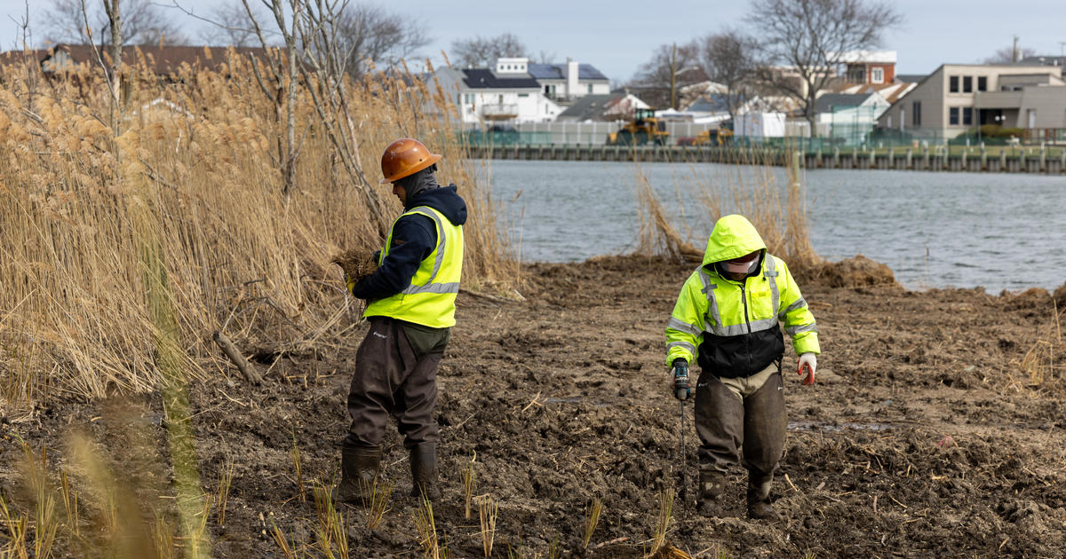
But the option to stay indoors is not available to a crew with the U.S. Army Corps of Engineers, which is beach duty night and day for a post-Superstorm Sandy beach replenishment project.
"We'll just work around it the best way we can you know, long-johns -- you come prepared," said Mike Goudy of the Army Corps of Engineers.
Meanwhile, NJ TRANSIT said it planned to operate on a regular weekday schedule Tuesday, but might have to modify service if conditions change. The agency will implement full, systemwide cross-honoring during the storm.
In Hoboken, drivers were reminded not to park on emergency snow routes labeled with street signs reading, "No Parking When Road Is Snow Covered." A list of affected roads is available at www.hobokennj.org/snow.
Discounted parking will also be available at Hoboken municipal garages.
LINK: Check Forecast | City's Snow Response
The snow is forecast to start falling Tuesday afternoon and continue through the evening, CBS 2's Elliott forecast. Snow could linger into Wednesday morning, he said.
Blowing and drifting snow could also limit visibility, making for hazardous driving conditions.
You May Also Be Interested In These Stories