Severe Storms Blast Tri-State For Second Night In A Row
NEW YORK (CBSNewYork/AP) -- Severe thunderstorms pounded the tri-state area for the second night in a row Thursday, bringing torrential rain and leaving roads and subways flooded.
As the multiple storm systems pounded the area, many locations were swamped with more than 1 1/2 inches of rain.
Central Park saw a total of 1.74 inches of rain; Teterboro, New Jersey, saw 1.68 inches; Newark 1.24 inches; White Plains, New York, 0.78 inches; and Somerville, New Jersey, 0.43 inches, CBS 2 meteorologist Vanessa Murdock reported.
The storms also brought down trees and power lines, and caused dangerous lightning.
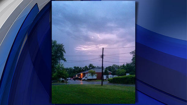
There were three injuries reported in the area as a result of lightning.
At 175th Street and Broadway in Washington Heights near the George Washington Bridge Bus Station, a tree came down and shut down the road completely.
The storms caused flooding that shut down subway service on a stretch of the Upper West Side late Thursday.
Due to flooding at the 79th Street station, the Nos. 1, 2 and 3 trains were shut down between 96th Street and Times Square-42nd Street for some time Thursday night. The lines resumed normal service by 10:30 p.m.
At the 125th Street A, B, C and D Train station in Harlem, the storms sent water cascading onto the track bed in what Instagram user Tai Verley called an urban waterfall.
Flooding was also seen in other subway stations, including the First Avenue L-train station in the East Village.
Another Instagram video showed commuters forced to tread through puddles of mucky water as they climbed the stairs out of the station.
On the Metro-North Railroad, a train hit a tree that had fallen onto the tracks on the Danbury Branch of the New Haven Line, leaving passengers stranded for an hour before they were transferred to another train. Service was disrupted after the accident.
Dangerous flooding was also seen on the roads in several municipalities, including Elizabeth, New Jersey. As CBS 2's Matt Kozar reported, one woman had to be rescued from her car.
There was nowhere for the water to go on the streets of Elizabeth and elsewhere in Union County. Some cars made it through, while the police and fire departments did their best to manage traffic and prevent cars from getting stuck in the water.
And in Chatham, New Jersey, in Morris County, the Fire Department responded to a home that had a tree fall on top of it. A few blocks away near the train station, floodwaters poured down the hill and created a trap for motorists.
Kim DeLaurentis took a chance in her Jeep, but could not get through.
"I was able to open the door, and as soon as I did open the door, the water started coming in, but it didn't reach the seat," DeLaurentis said. "It stayed about maybe six inches from the floor of the car."
Severe hail was also noted in some areas, including Hopatcong, New Jersey, where the marble-sized precipitation littered the ground.

The threat of storms prompted delays at all major area airports. Departures were delayed by over four hours at John F. Kennedy International Airport, Newark Liberty International Airport and LaGuardia Airport as of the 5 p.m. hour.
The delay times improved, but continued, as the night went on. Delays still topped out at three hours at Newark as late as 10:30 p.m.
And with a second day of storms came a second day of power outages. Jersey Central Power and Light reported 13,400 outages Thursday night; Public Service Electric and Gas in New Jersey reported 12,300; Orange and Rockland reported 3,500; PSEG Long Island reported 1,800; and Con Edison reported 1,600.
Meanwhile, the National Weather Service has also issued a flash flood watch through Friday morning because a cold front will interact with tropical air from Hurricane Arthur. Forecasters say the potential exists for 1 to 3 inches of rain.
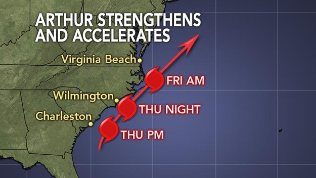
Arthur is expected to pass well off the New Jersey coast, but the storm is expected to churn the surf, keeping lifeguards on edge throughout the July Fourth holiday weekend.
As of midnight Thursday, Arthur was a Category 2 hurricane with winds of 100 mph and had made landfall between Cape Lookout and Beaufort in North Carolina. The tropical storm strengthened to a hurricane earlier in the day.
CHECK: Forecast & Alerts | Radar | Traffic & Transit | Interactive Storm Tracker From CBS Miami
Arthur made landfall late Thursday night near Cape Lookout the barrier islands of North Carolina. State Gov. Pat McCrory announced earlier Thursday night that 11 counts in that state are under a state of emergency, and 100 of the state's National Guard soldiers have been dispatched in advance for recovery efforts, CBS affiliates reported.
CBS News' Craig Boswell reported evacuations were ordered for Cape Hatteras and suggested for other areas. Many of the nearly 250,000 people on the Outer Banks decided to evacuate, while voluntary evacuations were advised for other areas.
Hurricane Arthur Expected To Churn Surf
In the latest advisory, a Tropical Storm Warning has been issued for Nantucket Island and for Cape Cod from Provincetown to Chatham.
Environment Canada has issued a tropical storm watch for Nova Scotia from Port Maitland Eastward and Northward to Point Aconi, CBS Miami reported.
The storm was expected to go out to sea after moving on early Friday. It was expected to be off the coast of New England later Friday and eventually make landfall in Canada's maritime provinces as a tropical storm, the Hurricane Center predicted.
No landfall or severe danger was anticipated for the tri-state area, but a rainy day was expected for the Fourth of July, and some strong winds were expected, particularly on the forks of Long Island.
Enhanced rip currents were also expected through the holiday weekend as Arthur moves up the coast. Beachgoers are cautioned to obey lifeguards and not swim at unguarded beaches.
"We're going to put the swimmers in the best spots possible for them to be as safe as possible and if something does go wrong, we're here to get out there and make sure everyone's safe," a lifeguard in Long Beach told WCBS 880's Sophia Hall. "If you're not an experienced swimmer, I wouldn't go past your waist."
Rainfall totals as a result of Arthur on Friday will amount to 1/2 to to 1 1/2 inches for most of the Tri-State Area, and up to 2 inches on Long Island, Murdock reported.
The rain should be finished in time for the Macy's Fireworks Spectacular on Friday evening.
Check Out These Other Stories From CBSNewYork.com:
(TM and © Copyright 2014 CBS Radio Inc. and its relevant subsidiaries. CBS RADIO and EYE Logo TM and Copyright 2014 CBS Broadcasting Inc. Used under license. All Rights Reserved. This material may not be published, broadcast, rewritten, or redistributed. The Associated Press contributed to this report.)