1/31 CBS2 Saturday Evening Weather Headlines
By Mark McIntyre Jr, CBS2 Meteorologist/Weather Producer
All I can say is BRRRR! It's sure been a frigid day across the region and gusty winds haven't helped us one bit! Good news though: winds will be much weaker tonight, but you'll still want to bundle up with a low around 20 in town, teens elsewhere. Chills will be in the single digits to teens overnight.
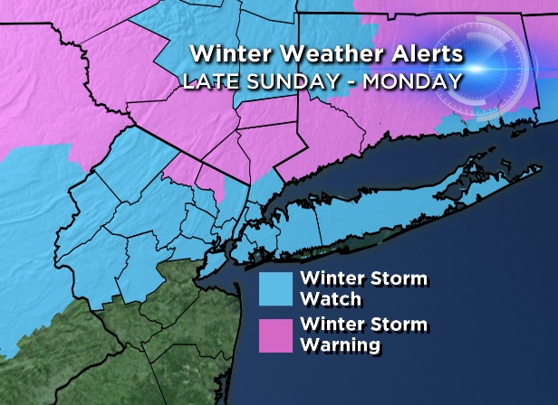
Clouds creep in during the day tomorrow and temps look to make it into the low 30s. Much of the morning should be dry, but heading through the late afternoon some folks in western New Jersey and also in the Lower Hudson Valley could be seeing some flakes fly. The real activity will start after midnight though, with a wintry mess and treacherous travel.
Expect mainly snow in Sullivan/Ulster/Dutchess, a mix of snow/sleet/freezing rain closer to I-84, potentially significant icing for northeast New Jersey, Westchester/Orange/Rockland, NYC and North Shore Long Island/coastal Connecticut and potentially heavy rain for South Shore and Jersey Shore. City looks like 4-8" of snow from S-N (Central Park closer to that low end) but with a more serious threat of up to 1/4" of ice...which is very bad news. 8"+ for the northernmost 'burbs, less than an inch of snow for the south-facing coasts, but heavy rain. We'll need to keep tweaking this as we get closer to the event.
Temps plunge behind the storm Monday night into Tuesday morning, waking up with single digits in NYC and below zero elsewhere. Throw some northwest winds into the mix for an even colder feel. Stay tuned for the very latest regarding the upcoming storm!